Catalog Archive
Auction 163, Lot 366

Rare and Important Map That Helped Establish Independent Texas' Eastern Border

"Sabine Pass and Mouth of the River Sabine in the Sea. Surveyed Under the Direction of Major J.D. Graham U.S. Top Engineers...", U.S. Government

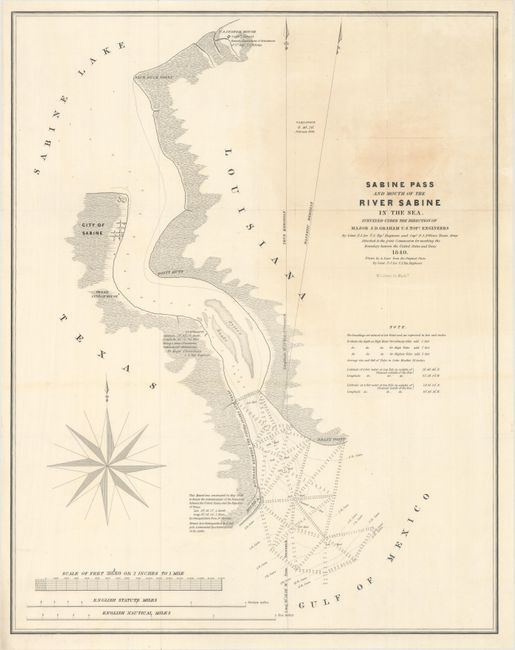
Subject: Texas-Louisiana Border

Period: 1840 (dated)

Publication: Sen. Ex. Doc. 199, 27th Cong., 2nd Sess.

Color: Black & White

Size:
17.7 x 22.4 inches
45 x 56.9 cm
Download High Resolution Image
(or just click on image to launch the Zoom viewer)

This map is among the most important government maps during the period of Texas independence. It was produced for the report of the Joint United States-Texas Boundary Commission, which for the first time depicted the eastern border of Texas. This map covers the section from Sabine Lake to the Gulf of Mexico and shows soundings, Sabine City, and the U.S. Customs House. It was surveyed under the direction of Major J.D. Graham, U.S. Topographical Engineers, by Lt. T.J. Lee of the U.S. Topographical Engineers and Capt. P.J. Pillans of the Texan Army, and drawn by A. Zeyer from Lt. Lee's original plates. Engraved by W.J. Stone and published in 1842. It is a rare, and important part of Texas' cartographic history.

References: Claussen & Friis #412; Day #952E; Martin & Martin p. 36.

Condition: B+

Issued folding with a light stain at top right and a short edge tear at top that has been closed on verso with archival materials.

Estimate: $450 - $550

Sold for: $300

Closed on 6/14/2017

Archived