Subject: South Carolina Coast
Period: 1862 (dated)
Publication:
Color: Black & White
Size:
35.1 x 19.9 inches
89.2 x 50.5 cm
The Office of Coast Survey is the oldest U.S. scientific organization, dating from 1807 when Congress directed that a "survey of the coast" be carried out. By 1836, it was called the U.S. Coast Survey and in 1878, the name was changed to the U.S. Coast and Geodetic Survey. Today the Office of Coast Survey is a division of the National Oceanic and Atmospheric Administration NOAA.
The survey teams, composed of civilians as well as Army and Naval officers, charted the nation's waterways and produced a wide array of reports, survey charts, hydrographic studies of tides and currents, astronomical studies and observations, and coastal pilots. These charts are an important record of the changing nature of the nation's coastlines. In additional to coastal charts, the U.S. Coast and Geodetic Survey produced land sketches, Civil War battle maps, and the early aeronautical charts.
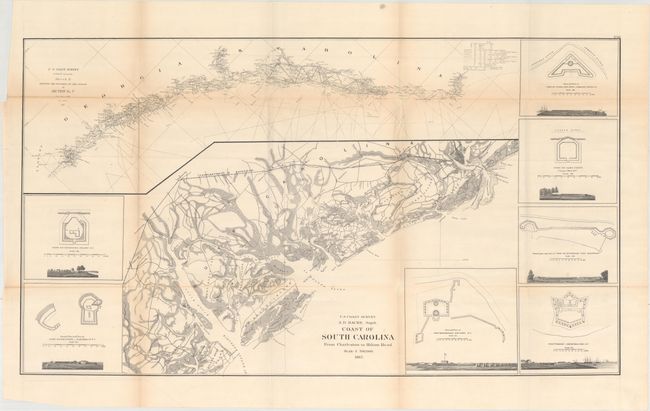
This map shows the coastline of South Carolina from Hilton Head Island to Charleston. In the upper portion of the image is an inset of the progress of the Coast Survey in both Georgia and South Carolina. Along the perimeter of the map are illustrations of seven different forts in the state, including Fort Walker on Hilton Head Island.
References:
Condition: B+
Issued folding with light toning along the folds and two 3" fold separations at top left that have been closed on verso with archival tape.