Subject: Washington, D.C.
Period: 1794 (dated)
Publication: The American Geography
Color: Black & White
Size:
8.4 x 6.6 inches
21.3 x 16.8 cm
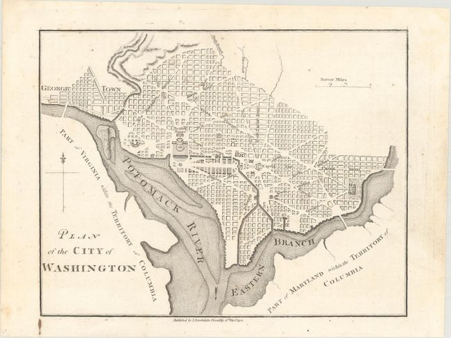
This is a reduced and simplified version of Ellicott's plan of 1792, and appeared in Stockdale’s London printing in 1794 of Jedidiah Morse’s rare The American Geography, containing 25 maps. This is the earliest compilation of maps and descriptions regarding the early states and territories within the United States. Based upon “The Philadelphia Plan” drawn by Thackara and Vallance two years earlier, this plan shows Washington bordered by the Potomack (Potomac) River and the Eastern Branch, now the Anacostia River. Georgetown, at the left and northwest of Rock Creek, is separately labeled. Reedy Branch and Tiber Creek are shown to the north outside of the street pattern. Only the Capitol and Presidents House are labeled; other buildings are merely outlined. The proposed landscape design for the Mall is shown with some detail. Published by John Stockdale on September 16, 1794. This plate was used again with a number of revisions in Isaac Weld's Travels Through the States of North America..., published in 1798. No individual sales for this 1794 map have been located.
References: Howes #M840; McCorkle (18th C. Geography Books) #302 [15]; Sabin #50924.
Condition: A
A nice impression on paper with an "I Z LEP" watermark and a few faint spots of foxing.