Subject: South Dakota
Period: 1891 (circa)
Publication:
Color: Black & White
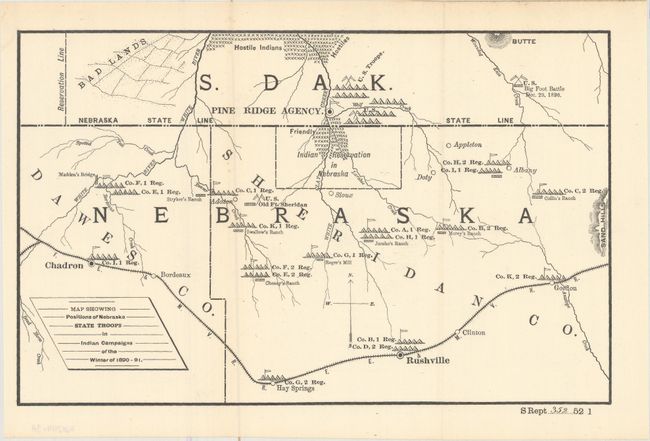
A. Map Showing Positions of Nebraska State Troops in Indian Campaigns of the Winter of 1890-91, by U.S. Government, circa 1891 (12.1 x 7.6"). This fascinating map has considerable historical significance in that it shows the location of the Battle of Wounded Knee, here labeled as Big Foot Battle, Dec 29, 1890. A misunderstanding between soldiers and Indians waiting to surrender at Wounded Knee, South Dakota, touched off the tragic massacre of some 300 Sioux men, women and children. The campaign was an attempt to suppress the Ghost Dance movement. At the height of the tension, Sitting Bull was killed. The map covers a portion of South Dakota and Nebraska and includes Madden's Bridge, the Stryker, Chaney, Swallow, Jarcho, Morey and Collin Ranches, and the towns of Pine Ridge, Gordon, Rushville, and Chadron. Military positions are shown throughout, with notes of friendly and hostile Indian locations.
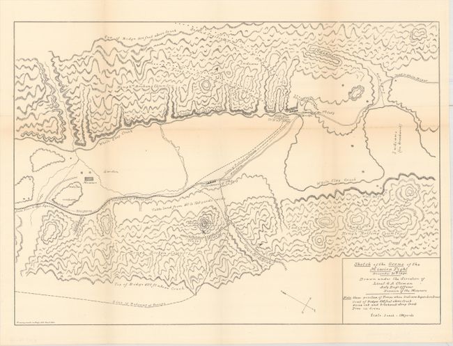
B. Sketch of the Scene of the Mission Fight December 30th 1890..., by Lieut. S.A. Cloman, (17.1 x 12.2"). This uncolored map was drawn under the Direction of Lieut. S.A. Cloman, Act'g Eng'r Officer Division of the Missouri. This highly detailed map is drawn on a scale of 1 inch = 150 yards. The various positions of the 7th and 9th Calvary are shown. The Indian warrior positions and their lines of retreat are also noted. It locates the wagon roads from Pine Ridge Agency and to White River; names White Clay Creek, the (Drexel) Mission and garden, and shows the topography in great detail.
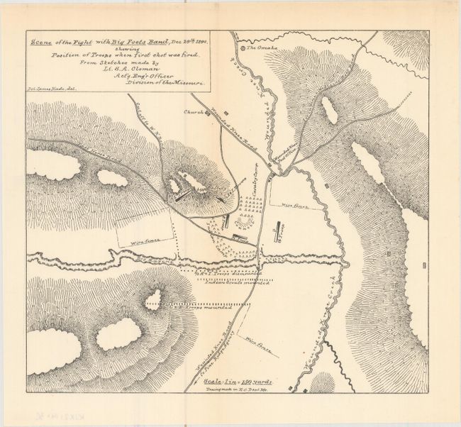
C. Scene of the Fight with Big Foots Band, Dec 29th 1890. Showing Position of Troops When First Shot Was Fired..., by Lieut. S.A. Cloman, (8.4 x 7.5"). Also drawn at a scale of 1 inch = 150 yards, the map is highly detailed. It indicates the positions of mounted and unmounted troops, the Cavalry Camp, G Troop, Indian Scouts, and more; names Wounded Knee Creek, Wounded Knee Road, the Porcupine x Medicine Root Road, and the cutoff to W.K. Road. Drawn by Pvt. James Hade.
The two Cloman maps (B & C) were one of the key pieces of evidence used during the Wounded Knee Investigation, and was used by most of the officers asked to provide testimony.
References:
Condition: B+
Issued folding with light toning along some folds.