Subject: Southern United States
Period: 1798 (dated)
Publication: The American Gazetteer
Color: Hand Color
Size:
15.1 x 7.7 inches
38.4 x 19.6 cm
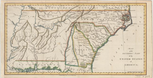
This early map of the southern region of the United States is based on Abraham Bradley's map of the same title. It reflects the primitive state of settlement west of the Appalachian Mountains. The map extends from the Atlantic to the Mississippi River, and from the southernmost parts of Kentucky and Virginia to the Gulf Coast. The young state of Tennessee is shown with the central region labeled Mero District. Georgia Western Territory comprises most of what would become Mississippi and Alabama. This region was claimed by both the United States and Georgia during this period. The Spanish possessions of West and East Florida are shown. The Okefenokee Swamp is labeled as the Ekanfanoka Swamp. Knoxville, Mobile, New Orleans, Nashville, and Raleigh are all named. Engraved by John C. Russell and published by Charles Dilly.
References:
Condition: B+
Issued folding on watermarked paper with a binding trim at lower left that has been replaced with old paper. There is very faint offsetting at right from an opposing page of text and there are remnants of hinge tape on verso.