Subject: France
Period: 1541 (published)
Publication: Claudii Ptolemaei Alexandrini Geographicae…
Color: Hand Color
Size:
14.6 x 10.9 inches
37.1 x 27.7 cm
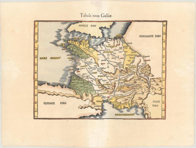
Claudius Ptolemy was a mathematician, astronomer and geographer who worked in Alexandria, then a part of the Roman Empire, in the 2nd century AD. One of the most learned and influential men of his time, his theories dominated both astronomy and geography for nearly 1500 years. His writings were kept alive by Arabic scholars during the Middle Ages and reemerged in Europe during the Renaissance. The birth of printing led to wide dissemination of his great works on astronomy and geography. There were a number of editions of his Geographia beginning in 1477. These early editions contained maps based on his original writings, known as Ptolemaic maps. As geographic knowledge increased with the explorations of Columbus, Magellan, Cabot and others, maps of the New World were added, and maps of the Old World were revised. Ptolemy's Geographia continued to be revised and published by some of the most important cartographers including Martin Waldseemuller, Sebastian Munster, Giacomo Gastaldi, Jodocus Hondius, and Gerard Mercator (whose last edition was published in 1730).
This Ptolemaic map is centered on France, and extends to include present-day Belgium, the Netherlands, Luxembourg, Switzerland, and parts of Germany and Italy. Exaggerated mountain ranges and ancient place names fill the map. Blank verso.
References: Mickwitz & Miekkavaara #211-31.
Condition: B+
A crisp impression on paper with a bunch of grapes watermark, mild toning, a few tiny worm holes along the centerfold, and several minor creases.