Subject: Texas
Period: 1866 (dated)
Publication:
Color: Hand Color
Size:
26.1 x 16.8 inches
66.3 x 42.7 cm
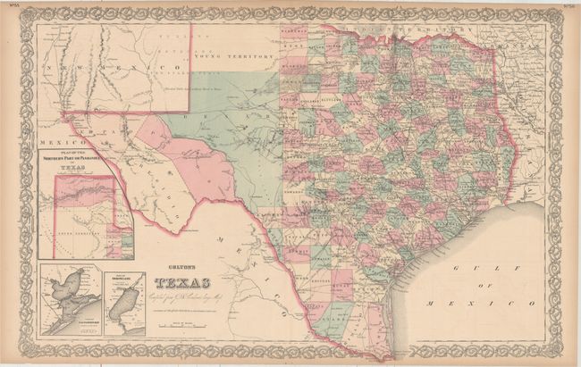
This later edition Colton is an interesting double page map that was first published in the 1850s as "New Map of the State of Texas Compiled from J. De Cordova s Large Map." The map presents extensive detail throughout the settled part of the state. The western third is comprised of the large unsettled areas of Presidio, El Paso, Pecos, Bexar Territory and Young Territory. With excellent detail of railroads, forts, post offices, roads, springs, watershed and topography. County development is current to 1866 with the addition of Kinney and Uvalde to the west of San Antonio. Includes the large inset "Plan of the Northern Part or Panhandle of Texas" plus three smaller insets Plan of Galveston Bay and Plan of Sabine Lake. This handsome sheet has fancy titling and a decorative scroll border.
References:
Condition: B+
Light toning along sheet edges and faint offsetting. Short centerfold separations confined to the top and bottom decorative borders have been closed on verso with archival tape.