Subject: Mid-Atlantic United States, Chesapeake & Delaware Bays
Period: 1852 (dated)
Publication:
Color: Hand Color
Size:
28.3 x 40.5 inches
71.9 x 102.9 cm
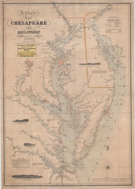
This large-scale sea chart of the Chesapeake and Delaware Bays is one of the most decorative and desirable charts of the area. The chart depicts great detail from the entrances to the bays on the Atlantic Ocean to Washington D.C., Baltimore, and Philadelphia, and extending up the James, York and Rappahannock rivers. Miniature bird's-eye plans of the key cities are shown, adding to the attractiveness of this chart. The waters are filled with soundings, shoals and other navigational hazards. Four profile views of the coast are depicted - Cape Henry, Smiths Point Light House, Windmill Point, and Cape Henlopen - three of which include lighthouses. Lighthouses and Light Boats are marked throughout the chart with notes about the lights at each. Another noteworthy feature is the inclusion of tide tables for both bays. Engraved by John and William Warr and sold by Hagger & Brother, a prominent Baltimore merchant of nautical charts in the mid-nineteenth century. Originally published in 1832, several editions appeared through 1862. This example has corrections through 1852. Printed on two sheets, joined as issued and mounted on original linen with the Hagger & Brother label on verso.
Fielding Lucas, Jr. was a successful cartographer and map publisher in Baltimore. Lucas is best known for his General Atlas of 1823, which is considered one of the finest general atlases produced in the U.S. at the time, due to the high quality paper, superior engraving quality, and attractive coloring style. This chart is the only chart known to be published by Lucas. It is significant for the innovative use of color to distinguish the navigational hazards and lighthouses.
References: Guthorn, p. 78.
Condition: B+
Original color with light soiling that is more prominent in the corners. There is minor creasing and some tiny spots of foxing in the bottom corners and at top right. There are several short cracks/tears along the edges of the sheet that have been professionally repaired. A very nice example of a sea chart that was intended for heavy use.