Subject: Central England
Period: 1675 (circa)
Publication: Britannia…
Color: Hand Color
Size:
17.1 x 13.1 inches
43.4 x 33.3 cm
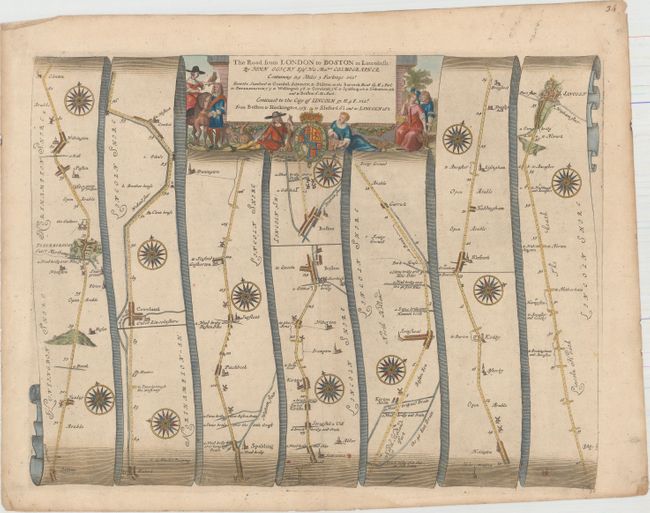
John Ogilby's 'Britannia' was published between 1675 and 1698. It is a landmark in the mapping of England and Wales. Its unique format constituted the first national road-atlas of any country in Western Europe. It was composed of maps of seventy-three major roads and cross-roads, presented in a continuous strip-form, on a uniform scale of one inch to a mile. Each beautiful map includes wonderful detail of the countryside with each strip containing a large compass rose to indicate changes in direction.
This attractive strip-style map covers 70 miles of roads in Cambridgeshire and Lincolnshire. It is in the pictorial style pioneered by Ogilby with the road laid out in several ribbon-like panels. Each of the seven panels has a decorative compass rose to orient the traveler. The route travels from Stilton, Cambridgeshire and proceeds in a northerly direction to Boston in Lincolnshire, continuing to the city of Lincoln. Embellished with a strapwork title cartouche featuring local hunters displaying their catches, including rabbits and fowl.
References: Moorland & Bannister, pp. 157-8; Shirley (BL Atlases) T.OGIL-4a #36.
Condition: B+
Watermarked paper with light soiling and minor extraneous creasing.