Subject: North Atlantic, Gulf Stream
Period: 1808 (dated)
Publication: Memoirs of the Life and Writings of Benjamin Franklin
Color: Black & White
Size:
13.7 x 12.4 inches
34.8 x 31.5 cm
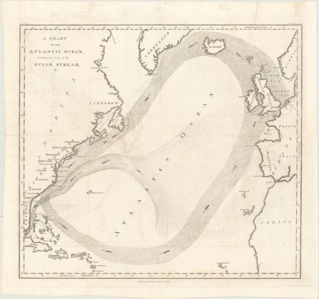
Benjamin Franklin first published his groundbreaking chart of the Gulf Stream in 1786 in A Letter from Dr. Benjamin Franklin ... Containing Sundry Maritime Observations, in Volume II of Transactions of the American Philosophical Society. The chart was intended to spur sea captains to alter their routes for quicker, more convenient travel. Franklin, who was Deputy Postmaster General for the Colonies, often received complaints regarding the amount of time it took to send mail to the Colonies. His cousin, Captain Timothy Folger, was a whaling captain and so Franklin inquired whether there might be a better sailing route. Folger described the Gulf Stream to Franklin and drew a sketch for him. Although the Gulf Stream had been well known to Spanish ship captains, who relied on it to sail from the Americas to the Iberian Peninsula, Spanish secrecy had kept this information and related charts from other maritime nations. Franklin began studying the Gulf Stream by making observations and charting water temperatures on his many trips across the Atlantic. Franklin began to distribute his findings along with Folger's map to British ship captains in 1767-70, but found that they largely ignored the information. It took the skeptical British years to follow Franklin's advice, but once they did their transatlantic journeys were about two weeks shorter.
This edition of Franklin's chart is an updated version, focusing on the migration of the herrings presented as the large outer loop, which previously had only appeared in a small inset on Franklin's original chart. The Gulf Stream is shown originating in the Florida Strait and fanning out from North American toward Europe and Africa. This version of Franklin's chart was included in an edition of his memoirs, which was published by William Duane in 1808. Duane had taken over Benjamin Franklin's printing company upon the death of Franklin's grandson in 1798. Since the cartographer of this chart is unknown, it is often referred to as the "Duane Map."
References:
Condition: B+
Issued folding, now flat, with minor offsetting and some tiny fold separations that have been repaired on verso with archival materials. A binding trim at top right has been replaced with old paper and the associated binding tear that does not enter the image has been archivally repaired.