Subject: Washington, D.C.
Period: 1852 (circa)
Publication: Maps of the District of Columbia and City of Washington...
Color: Black & White
Size:
20.5 x 16.8 inches
52.1 x 42.7 cm
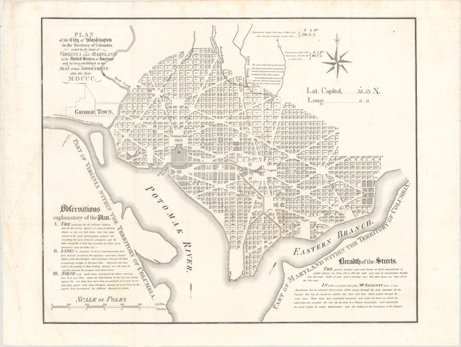
This was one of three maps published in A.B. Hamilton's Maps of the District of Columbia and City of Washington..., and is based on the 1792 plan published by Andrew Ellicott. The plan shows the layout of streets including the long diagonals. Washington is bordered by the Potomak (Potomac) River and the Eastern Branch, now the Anacostia River. Georgetown, at the left and northwest of Rock Creek, is separately labeled. Reedy Branch and Tiber Creek are shown to the north outside of the street pattern. Each block is numbered. A few major buildings including the Capitol and the Presidents House are labeled; others are merely outlined. The proposed landscape design for the Mall is shown with considerable detail. Unlike earlier editions, this version does not include soundings in the Potomac River, and there is no block detail in Georgetown. Near the upper right is an eight-pointed compass indicator surmounted by a fleur-de-lys, and at the lower left is a distance Scale of Poles.
References: Phillips (A) #3711.
Condition: B+
Issued folding on a bright sheet that has been flattened and backed with tissue to reinforce and repair an edge tear that extends 3" into the image at left. There is faint scattered foxing.