Subject: California
Period: 1852-61 (dated)
Publication:
Color: Black & White
The Office of Coast Survey is the oldest U.S. scientific organization, dating from 1807 when Congress directed that a "survey of the coast" be carried out. By 1836, it was called the U.S. Coast Survey and in 1878, the name was changed to the U.S. Coast and Geodetic Survey. Today the Office of Coast Survey is a division of the National Oceanic and Atmospheric Administration NOAA.
The survey teams, composed of civilians as well as Army and Naval officers, charted the nation's waterways and produced a wide array of reports, survey charts, hydrographic studies of tides and currents, astronomical studies and observations, and coastal pilots. These charts are an important record of the changing nature of the nation's coastlines. In additional to coastal charts, the U.S. Coast and Geodetic Survey produced land sketches, Civil War battle maps, and the early aeronautical charts.
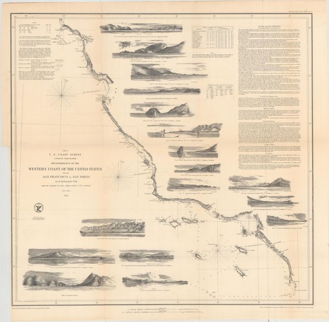
A. Reconnaissance of the Western Coast of the United States from San Francisco to San Diego..., dated 1852 (22.8 x 21.8"). This terrific chart delineates the coast and is from the first official scientific reconnaissance of the Pacific coastal areas. It is one of three prepared by Lieutenant James Alden for this important survey. This sheet covers the region from the Mexican boundary to Point Reyes. It outlines the coastal littoral, shows dangerous reefs and shoals, gives offshore bathymetric soundings, plus general and specific harbor sailing instructions. The most impressive feature is the 17 views of entrances and promontories along this rugged coastline - among them Santa Barbara, Catalina Harbor, and the entrance to San Francisco Bay. The map was drawn by W.M. McMurtie and engraved by G. McCoy. Engraving of the views is also by McCoy with S.V. Hunt. This is one of the finest Coast Survey charts produced, and should not be confused with the simpler, and slightly smaller, charts that do not feature the large number of coastal views. Reference: Heckrotte & Sweetkind #33. Condition: Light toning with a binding trim at left. (B+)
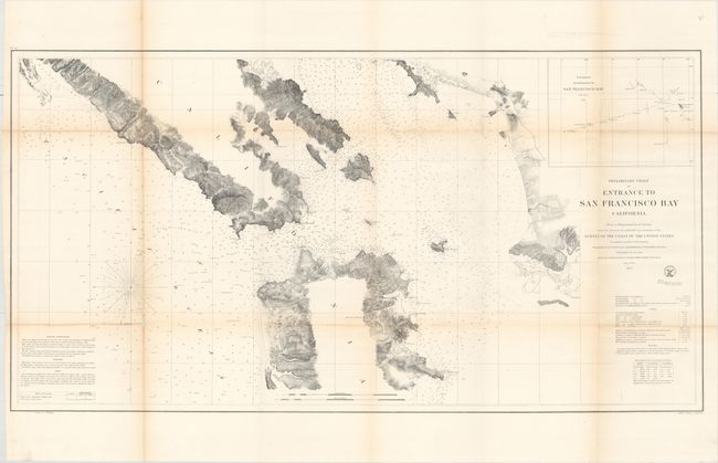
B. Preliminary Chart of Entrance to San Francisco Bay California from a Trigonometrical Survey..., dated 1856 (38.8 x 20.3"). This great coastal chart of the San Francisco Bay covers the Marin Peninsula, San Francisco, Mission de Dolores, and the eastern coastline from just above Brookes Island to San Antonio Creek. An early city plan of San Francisco and an inset, "Sub-Sketch of Entrance to San Francisco Bay," add interest. There is good detail along the shore and sailing directions, soundings and navigational hazards are described in text. Condition: Light toning along the folds and several short splits at fold intersections. There are three longer fold separations at far left. (B)
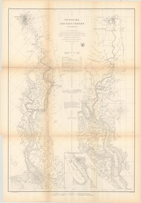
C. Petaluma and Napa Creeks California from a Trigonometrical Survey..., dated 1861 (20.8 x 29.8"). This chart details the Petaluma and Napa Rivers, both of which connect to San Pablo Bay. Bird's-eye plans of the cities of Petalama, Napa, and Vallejo are included. Condition: There is light toning along the folds and several splits at fold intersections. (B)
References:
Condition:
Issued folding. See description for additional details.