Subject: North Pacific Ocean
Period: 1776 (published)
Publication: Atlas Universel...
Color: Hand Color
Size:
24.9 x 17.9 inches
63.2 x 45.5 cm
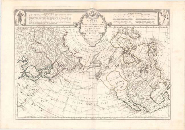
This is the authorized Venice edition of this cornerstone map of Alaska and the Pacific Northwest by Delisle/Buache. It depicts the discoveries of the Russians in the early 18th century, including the tracks of Bering's first and second voyages, Joseph Nicolas Delisle's voyage with Capt. Tchirikow in 1741, the track of De Frondat's voyage from China to California in 1709. The route of the Spanish Galleons from Acapulco to Manila in 1743 are also shown. These ships regularly carried immense quantities of gold and treasure along the route, until they were captured by Commodore George Anson in June 1743.
The west coast of North America is entirely fictitious north of Cap Blanc with an enormous Sea of the West, Lac Valasco, and Isle of Bernarda. A network of rivers and lakes making up most of a Northwest Passage is derived from the apocryphal voyages of the Spanish Admiral Bartholome de Fonte. The title appears in a rococo cartouche flanked by a native of Kamchatka in the upper left corner and a native of Louisiana in the upper right corner. This is the first state, with M. Remondini's imprint within the title cartouche.
References: Falk #1776-1; Kershaw #1225; Phillips (A) #647-44; Tooley (Amer) p. 35, #104; McGuirk #163.
Condition: A
Faint soiling at bottom left and a short printer's crease near center.