Subject: Korea
Period: 1797 (circa)
Publication: Atlas du Voyage de La Perouse...
Color: Black & White
Size:
27.3 x 19.6 inches
69.3 x 49.8 cm
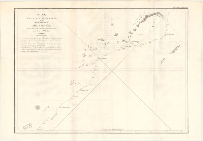
Jean-Francois de Galoup, Comte de La Perouse commanded a French scientific expedition to the Pacific in 1785-88. Recognized as one the foremost naval commanders and navigators in France, he was selected by King Louis XVI to complete Captain James Cook's exploration of the western Pacific. The British Admiralty provided scientific equipment to measure variations in magnetic compass readings and with the latest instruments for determining longitude. La Perouse explored the coasts of the Gulf of Alaska and northwestern North America in search of the fabled Northwest Passage. After leaving America his expedition continued on to Asia where he explored from Macao to Kamchatka and the Solomon Islands in the South Pacific. La Perouse was meticulous in sending copies of his extensive logs, maps and surveying information via other ships as well as overland. La Perouse's last contact was in the spring of 1788 with a British ship in Botany Bay, Australia. The expedition was never heard from again. Considered one of the greatest French voyages, the French Government decided to publish the story of the expedition when it became clear they had been lost. An English edition was published in London.
This detailed, large-scale map depicts the route of La Perouse's ships Boussoule and Astrolabe between the South Korean island of Jejudo (here called Ile Quelpaert) and the southern tip of mainland South Korea. La Perouse visited the area in July 1787. The Hallasan volcano is shown near the partial coastline of Jejudo, and numerous tiny islands are depicted throughout. Drawn by Herault and engraved by Bouclet.
References: Shirley (BL Atlases) G.LPR-1a #44; Mickwitz & Miekkavaara #132-21.
Condition: B+
A clean, bright example on watermarked paper with light offsetting. Issued folding.