Subject: Gulf of Mexico & Caribbean
Period: 1700 (circa)
Publication: Suite de Neptune Francois
Color: Hand Color
Size:
33.4 x 23.5 inches
84.8 x 59.7 cm
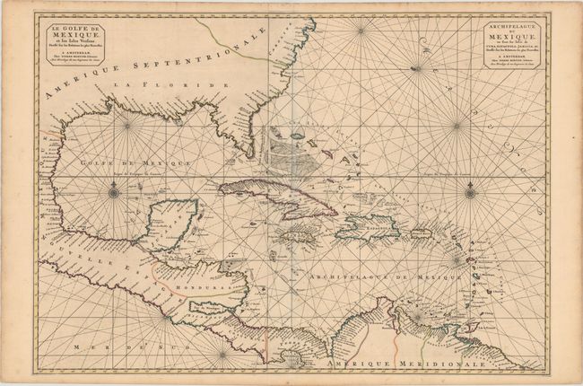
This stunning, large-scale chart is printed on two sheets with detail confined to the coastlines. It covers the U.S. coastline from just above Cape Fear (C. Faire) through the Gulf of Mexico, Central America, the northern coastline of South America and all of the West Indies. The name La Floridae covers the whole southern region reflecting the Spanish possessions. The cartography of Florida and the Southeast is very rudimentary, with a wide and truncated Florida peninsula.
In 1700 Pierre Mortier published the Suite du Neptune Francois as the second volume of his Neptune Francois of 1693. It covered regions outside of Europe with many drawn from the manuscripts of N.P. d'Ablancourt that were derived from Portuguese archives. There was only one edition of the Suite de Neptune Francois. However, some of the charts were issued in two separate sheets in Mortier's smaller format Atlas Nouveau. Unlike many of the other maps from the Suite, this map is rarer because it was replaced in 1703 by the Teatre de la Guerre en Amerique, a similar two-sheet map that illustrated the West Indian theater of the War of the Spanish Succession.
References: Burden #769.
Condition: B+
Strong, sturdy sheets with original outline color, minor offsetting, and a few small spots of foxing.