Subject: Western Pennsylvania
Period: 1805 (published)
Publication: Journal of a Tour in the Territory Northwest of the Allegheny Mountains…
Color: Black & White
Size:
9 x 13 inches
22.9 x 33 cm
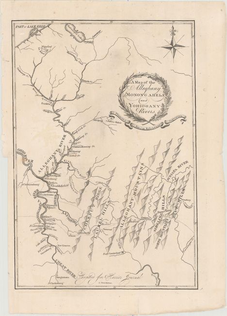
This is only the second time we've encountered this rarity. It was engraved by Thomas Wighman for Thaddeus Mason Harris' journal "Made in the Spring of the Year 1803." With a compass rose and fleur-de-lys at upper right but no scale. It shows Pittsburgh at left center and extends to Chatauque Lake in New York and Lake Erie in the north, south to Clarksburg and east to Strasburg on the Condigwinnet River. Names Fort Cumberland, Bedford, Grahams, Berlin, Somerset, Union, and Connelsville. Towns located along the valley of the Allegheny River include New Geneva, Morgantown, Greensburg, Bridgeport, Fredericktown, Canonsburg, Elizabethtown, Franklin and more. Also names Braddocksfield, Fort Fayette, Potter's Cabin, Burnt cabins near Fannetsburg. Dotted lines delineate the numerous trails in the region. The mountains and terrain are depicted with a series of shaded three-dimensional hills. Each range is named. The title is in a wreath-style cartouche with ribbon below containing the Latin phrase "Flumina Amen Sylvasque Inglorius" (trans: May I love the rivers and forests without fanfare). This rare issue was published in Boston.
References: Phillips (Maps) pp. 99 & 680.
Condition: B+
Issued folding and now flattened and backed with tissue. There are two short edge tears that just touch the border at left and one small area of faint offsetting.