Subject: Southwestern United States
Period: 1849 (dated)
Publication: Senate Ex. Doc. 12, 31st Cong., 1st Sess.
Color: Black & White
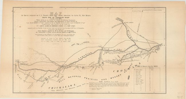
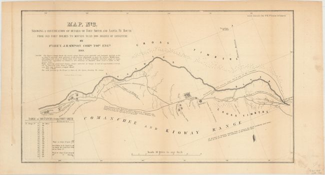
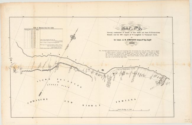
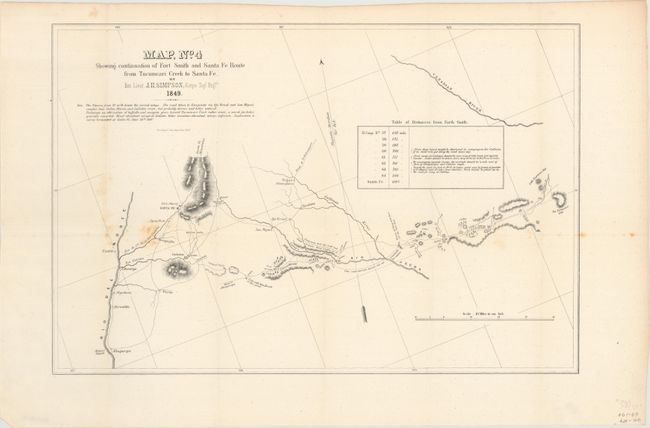
This historical and finely detailed set of maps covers the route of the expedition on a scale of 10 miles to the inch. The four sheets display the entire route, which initially crossed present-day Oklahoma, continued along the Canadian River to the llano Estacado in Texas' panhandle and finally into eastern New Mexico. Filled with details encountered along the way, it includes forts, rivers and creeks, topography, and many notes on wildlife, geological, emigrant roads, Indian tribes and villages, availability of water and wood. Every camp site is located and numbered. A table of distances appears on each map. One curious note just east of Albuquerque states that "Fish with legs found in this pond." This expedition represents the first detailed mapping of the area, and Simpson found the route to be "superior" and practicable for a railroad. The survey was made with a chain and compass checked by astronomical observations made with a sextant and chronometer. Simpson credits the surveys of the Canadian River and of New Mexico, made in 1845 - 46 & 47, by Lieut. T. Abert of the Topographical Engineers in the preparation of his maps. The maps were drawn by Lt. Simpson with the assistance of Mr. E.M. Kern and Mr. Champlin. Wheat notes the original drawings for these four maps are preserved in the National Archives. See Wheat Volume III for further details on the importance and accomplishments of Simpson' expedition.
A. Map of Route Pursued by U.S. Troops from Fort Smith, Arkansas, to Santa Fe, New Mexico, via South Side of Canadian River in the Year 1849... (19.1 x 10.9").
B. Map, No. 2. Showing a Continuation of Details of Fort Smith and Santa Fe Route from Old Fort Holmes to Mounds Near 100 1/2 Degree of Longitude (19.6 x 11.1").
C. Map, No. 3, Showing Continuation of Details of Fort Smith and Santa Fe Route, from Mounds Near 100 1/2 degree of W. Longitude to Tucumcari Creek (20.3 x 12.5").
D. Map, No. 4 Showing Continuation of Fort Smith and Santa Fe Route from Tucumcari Creek to Santa Fe (18.8 x 12.6").
References: Wheat (TMW) #640.
Condition: B+
Issued folding with light toning and some minor scattered foxing.