Subject: Hawaii
Period: 1784 (published)
Publication: Troisieme Voyage de Cook, ou Voyage a l'Ocean Pacifique…
Color: Hand Color
Size:
18.3 x 11 inches
46.5 x 27.9 cm
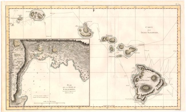
Although the first printed map of Hawaii is credited to Captain James Cook, it was prepared for publication by Lieutenant Henry Roberts, who prepared all of the maps for the three-volume narrative of Cook's final voyage. Roberts drew the map from a now-missing survey by William Bligh (of Mutiny on the Bounty fame) who was Sailing Master on the HMS Resolution. The map is a landmark in Hawaiian cartography and provided the basis for all subsequent mapping of the islands. The routes of the Resolution and the Discovery around the islands are carefully traced with nice topographical detail on each island. A large inset of La Baye de Karakakooa (Kealakekua Bay) is featured with details of soundings, navigational hazards and the anchorages of the two ships, and quaint depictions of houses, palm trees, and fields inland. Cook spent his last few weeks in Kealakekua Bay before dying in a confrontation with natives on February 14, 1779. This example is from the first French edition of Cook's voyages, A Voyage to the Pacific Ocean, which appeared the same year as the original English edition. Engraved by Benard from Henry Roberts' chart.
References: Shirley (BL Atlases) G.COOK-4a #16; cf. Fitzpatrick, pp. 15-18, plt. 2.
Condition: B+
Issued folding and now flattened on watermarked paper with a few minor spots in the image. The left side of the sheet has been remargined due to binding trim. Several folds have been reinforced on verso with archival tape.