Subject: Pacific Ocean
Period: 1715 (circa)
Publication:
Color: Hand Color
Size:
22.3 x 19.5 inches
56.6 x 49.5 cm
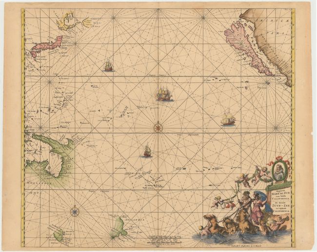
Second state of De Wit's superb mariner's chart of the Pacific Ocean showing the island of California, published by Renard. California is depicted with an indented northern coast on the second Sanson model, copied from Pieter Goos' Paskaerte van Nova Granada, en t'Eylandt California from 1666. The important Dutch discoveries are noted on the northern coast of Australia, Carpentaria, New Guinea, Anthoni van Diemens Landt (Tasmania) and New Zealand. North of Japan the discoveries of De Vries are shown along with disembodied sections of 't Land van Eso and Compagnies Lant. De Wit has omitted the chain of islands and hypothetical coastline of the southern continent that is commonly found on maps of this period. Instead he has presented a fairly good view of the few known Pacific Island groups. The chart is adorned with rhumb lines, sailing ships, sea battles and a compass rose. The allegorical title cartouche features a portrait of Magellan, cherubs, and Neptune with a female consort riding a brace of sea-horses. This chart covers an area from the equator to 50°N.Lat. and south to 45°S. Lat.
References: McLaughlin #59-2; Tooley (Australia) #1372; Tooley (Amer) p. 122, #40.
Condition: B+
A nice impression with attractive color, light toning, and a few minor stains. There is an archivally repaired centerfold separation that enters 1/2" into map at bottom.