Subject: Western Hemisphere
Period: 1838 (circa)
Publication: Corso di Geografia Universale
Color: Hand Color
Size:
20 x 19.8 inches
50.8 x 50.3 cm
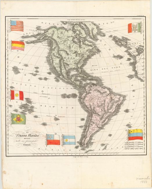
On this map of the "New World" North America is named Colombia and South America is named America. The name Columbia first appeared in 1738, and was meant to represent the European colonies in the New World, and later became the female personification of the United States of America. On this map the mountain ranges and river systems are well defined, although not entirely accurate; the mythical L. Xarayes still appears in South America. Numerous place names are noted throughout, although boundary lines between countries and states are not delineated. The map includes good detail of the surrounding islands, and features eight national flags: the United States, Haiti, Peru, Brazil, Chili, Argentina (referred to as Buenos Ayres), Colombia, and Mexico. Interestingly, the United States flag is depicted with 15 stripes and 26 stars in the formation of a star. The US flag added its 26th star in January 1837, when Michigan gained statehood, and didn't add another star until 1845. The 26-star flag was presented with two different star formations - arranged both in horizontal lines and in a star formation - but always with 13 stripes, although there was a period from 1795-1818 during which the US flag had 15 stripes and 15 stars. Engraved by Castellini.
References:
Condition: B+
Issued folding on watermarked paper with small, scattered stains, two minute worm holes, and a few tiny fold separations that have been archivally repaired. There is minor crumpling along sheet edges, not affecting map.