Subject: Pacific Ocean
Period: 1797 (published)
Publication: Atlas du Voyage de la Perouse
Color: Black & White
Size:
27.5 x 20 inches
69.9 x 50.8 cm
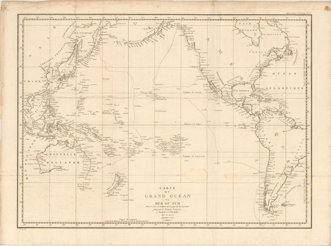
Jean-Francois de Galoup, Comte de La Perouse commanded a French scientific expedition to the Pacific in 1785-88. Recognized as one the foremost naval commanders and navigators in France, he was selected by King Louis XVI to complete Captain James Cook's exploration of the western Pacific. The British Admiralty provided scientific equipment to measure variations in magnetic compass readings and with the latest instruments for determining longitude. La Perouse explored the coasts of the Gulf of Alaska and northwestern North America in search of the fabled Northwest Passage. After leaving America his expedition continued on to Asia where he explored from Macao to Kamchatka and the Solomon Islands in the South Pacific. La Perouse was meticulous in sending copies of his extensive logs, maps and surveying information via other ships as well as overland. La Perouse's last contact was in the spring of 1788 with a British ship in Botany Bay, Australia. The expedition was never heard from again. Considered one of the greatest French voyages, the French Government decided to publish the story of the expedition when it became clear they had been lost. An English edition was published in London.
Jean-Francois de Galaup, Comte de La Perouse commanded a French scientific expedition to the Pacific in 1785-88. Recognized as one the foremost naval commanders and navigators in France, he was selected by King Louis XVI to complete Captain James Cook's exploration of the western Pacific. La Perouse explored the coasts of the Gulf of Alaska and northwestern North America in search of the fabled Northwest Passage. After leaving America his expedition continued on to Asia where he explored from Macao to Kamchatka and the Solomon Islands in the South Pacific. This large-scale map depicts the explorer's route from Brazil, to the northwest coast of America, through Asia, and ending in Australia. The map focuses on coastal details and the islands of the Pacific, with the interiors left blank. Australia, New Zealand, Papua New Guinea, and numerous islands of the south Pacific are still not fully delineated. Although La Perouse's journey ended in shipwreck in 1788 in the Santa Cruz Islands, his narrative, maps and views survived and were published in 1797. Engraved by Tardieu.
References: Tooley (Australia), p. 111, #834; Wagner #838; Falk (Alaska) #1797-6.
Condition: B
Wide margins on watermarked paper with old folds to accommodate binding into a book. One short fold separation in bottom margin that does not enter map image, and one tear that enters map image 1" at bottom. There are two faint damp stains in blank area of map image, and top blank margin has some damp stains with crumpled sheet edges.