Subject: Java, Indonesia
Period: 1726 (circa)
Publication: Oud en Nieuw Oost-Indien
Color: Hand Color
Size:
68.5 x 18 inches
174 x 45.7 cm
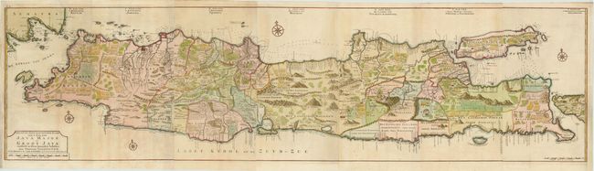
This remarkable, large-scale map of Java measures almost six feet long. It is richly engraved with details of agricultural fields, roads, temples, and topography. The coastline is filled with soundings, anchorages, shoals and other navigational hazards. Batavia, which was the center of the Dutch trading empire in the East Indies, is depicted with a miniature bird's-eye plan. Valentyn was a prominent historian of the Dutch East India Company who is best known for Oud en Nieuw Oost Indien, his vast illustrated account of the Dutch trading empire in Asia. He twice traveled to the East Indies and served as Calvinist minister to Ambon between 1686 and 1694. In preparing this monumental work, he was given privileged access to the previously secret archives of the VOC, containing transcripts and copies of important earlier Dutch voyages. The map was drawn and engraved by Jan van Braam and Gerard onder de Linden. Printed on seven sheets, joined.
References: Shirley (BL Atlases) #G.VALN-1a, #28-34.
Condition: B+
Lovely color with light toning and a few areas of faint offsetting. Binding trims at right and left have been professionally repaired to accommodate framing. A small hole in Panaraga has been repaired with a minute amount of image in facsimile. There is a fold separation that enters image 1" at top left, and a tear that enters image 1" at right, that have both been professionally repaired. Overall this map is in very good condition for such a large map.