Subject: Western Hemisphere
Period: 1548-58 (circa)
Publication: Cosmographia
Color: Hand Color
Size:
13.3 x 10.5 inches
33.8 x 26.7 cm
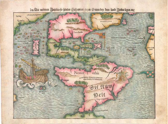
This map of the New World is often credited with popularizing the name America due to the popularity of Munster's Cosmographia and the numerous editions published in the sixteenth century. The influence of Marco Polo's 13th century explorations in Asia are evident with the 7448 islands in the North Pacific and Zipangri (Japan) shown only a short distance off the western coast of North America. The North American continent is very oddly shaped without a California landmass and the eastern region is nearly bisected by a body of water, known as the Sea of Verrazzano. The Yucatan is still shown as an island, Cozumel is named nearby as Cozumela, and the lake at Temistitan is connected to the Gulf of Mexico. South America has a large bulge on the western coast, the Amazon River is very short, and cannibals inhabit the continent shown with the name Canibali next to a gruesome vignette with human limbs. The map is very decorative with Magellan's surviving ship Victoria appearing in the Pacific. The flags of Spain and Portugal depict their respective spheres of influence in the New World. The German title is also on the verso set within an architectural surround.
References: Burden #12, state 11.
Condition: A
Marginal toning and two minute worm holes near ship, only visible when held to strong light. Short centerfold separation in top and bottom blank margins have been professionally repaired.