Subject: United States
Period: 1858 (dated)
Publication:
Color: Hand Color
Size:
17.5 x 10.8 inches
44.5 x 27.4 cm
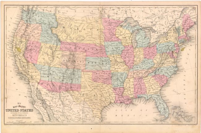
This map was published at a time when western territories were in a transitional period. It includes the important Confederate Territory of Arizona that was created under General Baylor. Earlier editions contained the inset "No. 6 Map of the Gold Region of California" but it is removed here so Arizona is clearly visible. Oregon has just attained statehood surrendering its eastern territory leaving Washington extending to the Continental Divide in its invented "L" configuration. The large Dakota Territory includes present-day Montana. Colorado territory has been formed from Utah and Kansas territories. The Gold Region is located in Colorado just southeast of Denver and adjacent to Cherry Creek. The proposed Nevada Territory is shown occupying the western part of Utah Territory and the portion of California east of the Sierra Nevadas. The Washoe Silver Mines are clearly noted north of Virginia City. Dated 1858 but published circa 1861. A fascinating Civil War period map.
References:
Condition: B
There are two small stains in the map - one in California and one just off the coast of New Jersey along with a pencil notation off the coast of South Carolina. There is a small centerfold separation that just extends past the neatline and some minor soiling.