Subject: United States
Period: 1830 (circa)
Publication:
Color: Hand Color
Size:
9.8 x 8 inches
24.9 x 20.3 cm
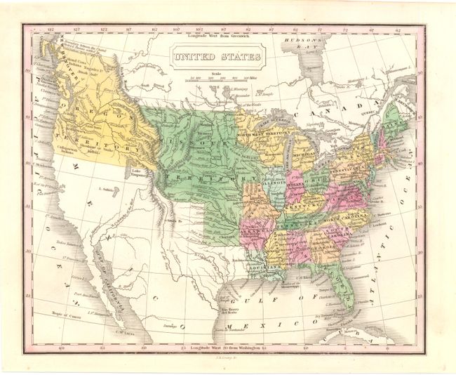
The United States and Great Britain established in 1818 joint claim over the Oregon Territory - the region north of Spanish controlled Upper California up to the southern boundary of Russia's Alaska Territory at North latitude 54°40'. By the late 1830's this arrangement was beginning to fall apart.
In the 1840's the expansionist Democrats, including their 1844 presidential candidate, James Polk, claimed the entire region for the United States. Their expansionist desires were expressed by Polk's famous campaign slogan, "Fifty-four Forty or Fight!" The slogan also became a rally cry for Americans desiring to settle the territory. Following Polk's election, the dispute was resolved by the 1846 Treaty of Oregon, which struck a compromise that fixed the U.S./Canadian boundary at 49º North.
This is an interesting small map covering the United States and the adjoining parts of Canada and Mexico. It shows the United States following the Missouri Compromise with both the state and territory of Missouri depicted. It shows the United States in control of present-day British Columbia with the "Boundary between the United States & Russia settled by Convention April 5th...1824." The boundary with Mexico is per the Treaty of 1819. Missouri Territory encompasses the entire Great Plains from Texas to Canada and from the Mississippi River to the Rocky Mountains. Other territories include Michigan, North West and Arkansas, the capital of which is Little Rock or Arkopolis. The map presents a particularly good view of the rivers and Indian nations in the West.
References:
Condition: A