Subject: North America
Period: 1845 (circa)
Publication:
Color: Hand Color
Size:
12 x 8.8 inches
30.5 x 22.4 cm
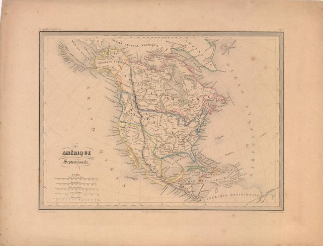
The United States and Great Britain established in 1818 joint claim over the Oregon Territory - the region north of Spanish controlled Upper California up to the southern boundary of Russia's Alaska Territory at North latitude 54°40'. By the late 1830's this arrangement was beginning to fall apart.
In the 1840's the expansionist Democrats, including their 1844 presidential candidate, James Polk, claimed the entire region for the United States. Their expansionist desires were expressed by Polk's famous campaign slogan, "Fifty-four Forty or Fight!" The slogan also became a rally cry for Americans desiring to settle the territory. Following Polk's election, the dispute was resolved by the 1846 Treaty of Oregon, which struck a compromise that fixed the U.S./Canadian boundary at 49º North.
This finely engraved map illustrates the westward expansion period of the United States, as its boundaries extend into present-day Canada in the Northwest, while Mexico still occupies California and the Southwest. The border drawn into British Columbia represents the United States' claims in the Fifty-four Forty or Fight! dispute. Alaska is named Amerique Russe and Canada is Nouvelle Bretagne. The Caribbean islands are well shown. Published by P. Bellier in Paris.
References:
Condition: B+
Even brown toning and a few spots in the image.