Subject: North America
Period: 1822 (circa)
Publication:
Color: Hand Color
Size:
8.8 x 12 inches
22.4 x 30.5 cm
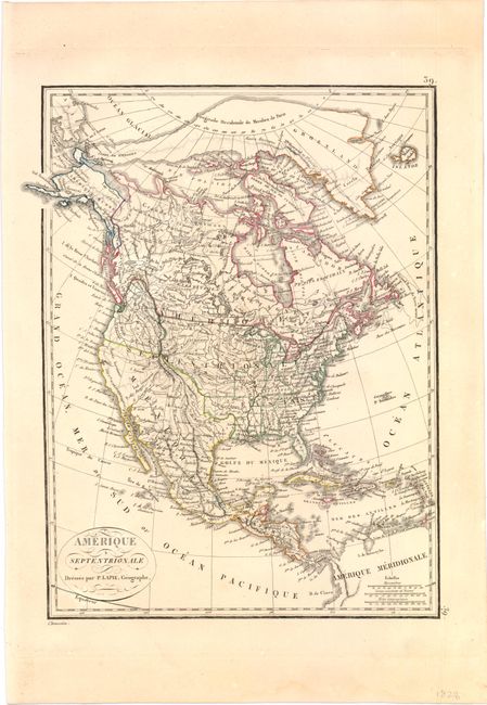
The United States and Great Britain established in 1818 joint claim over the Oregon Territory - the region north of Spanish controlled Upper California up to the southern boundary of Russia's Alaska Territory at North latitude 54°40'. By the late 1830's this arrangement was beginning to fall apart.
In the 1840's the expansionist Democrats, including their 1844 presidential candidate, James Polk, claimed the entire region for the United States. Their expansionist desires were expressed by Polk's famous campaign slogan, "Fifty-four Forty or Fight!" The slogan also became a rally cry for Americans desiring to settle the territory. Following Polk's election, the dispute was resolved by the 1846 Treaty of Oregon, which struck a compromise that fixed the U.S./Canadian boundary at 49º North.
This is an early 19th century map of the continent showing the United States in an evolving configuration. The boundary between the United States and Canada reflects the United States claims in the disputed Columbia region (Oregon). Arkansas Territory is shown in its largest extent with the new state of Missouri depicted. Spain is shown in control of the present-day Southwest, including Texas which is marked on the map. Alaska is named "Amerique Russe". Engraved by Chamouin.
References:
Condition: A
A hint of toning, else fine.