Subject: India
Period: 1851 (dated)
Publication: Illustrated Atlas and Modern History of the World
Color: Hand Color
Size:
9.8 x 13 inches
24.9 x 33 cm
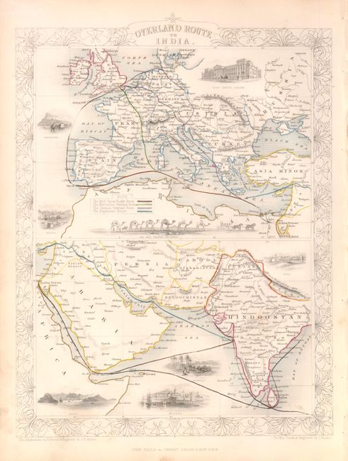
The maps from The Illustrated Atlas were first published in serial form to a target audience that led insular lives due to the expense and hardship of travel. All that changed as the progress of the nineteenth century brought swift and dramatic changes in public awareness of far away places. Tallis' maps no doubt played an important role in this dramatic awakening. These maps not only provided up-to-date geographical knowledge, but also used vignette views within the map's design to show the native people and their occupations, cities and points of interest. The maps hark back to a cartographic tradition from the Dutch mapmakers of the seventeenth century with finely engraved decorative borders. The maps were drawn and engraved by John Rapkin with views drawn and engraved by a number of prominent artists. The maps were issued as a complete volume from 1851 until about 1865. Some of the maps were also published in other history books published by Tallis including British Colonies and, without the vignettes, in geographical dictionaries and encyclopedias until about 1880.
Two maps showing routes from Europe to India over land and by sea. The top map showing Europe includes vignettes of Post Office in London, Gibraltar, Malta and the Mail Crossing the Desert by way of camel caravan. Arabia and India are shown at the bottom with vignettes of Suez, Aden, Bombay and Madras. An ornate outline border surrounds the two maps. Maps drawn and engraved by John Rapkin, with vignettes drawn by H. Warren and engraved by J.H. Kernot.
References:
Condition: A
The original outline color is typical for the period in that is was applied when children were employed as colorists. Map is in very good condition with some minor soiling in the lower blank margin. Right blank margin is slightly crumpled where the map was bound.