Subject: Western United States
Period: 1853-56 (dated)
Publication:
Color: Hand Color
Size:
11.3 x 16.8 inches
28.7 x 42.7 cm
During the 1850s, the U.S. government sponsored an extensive series of expeditions designed to gather information on the vast new territories that had been acquired in western North America. The discovery of gold in California further stimulated westward traffic and heightened the need for a faster and more convenient way to bring the far-flung parts of the country together. In 1853 Congress commissioned the Army's Topographic Bureau to conduct a series of surveys to find a suitable route for a transcontinental railroad. There were six major expeditions; five of them covered the area between the Great Plains and west coast, and the sixth explored the coastal states of California and Oregon. All of these expeditions were accompanied by naturalists and artists to document the landscape, flora and fauna along the route.
The reports, maps and lithographs were published in the 13 volume report "Explorations and Surveys to ascertain the most practicable and economical route for a Railroad from the Mississippi river to the Pacific Ocean."
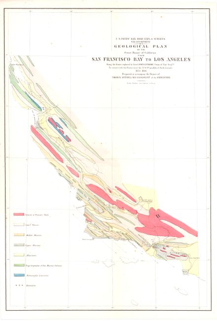
A. Geological Plan of the Coast Range of California from San Francisco Bay to Los Angeles, (11 x 17"). This colorful map details the coast and coastal mountain range between San Francisco and Los Angeles. Names Point Conception, Santa Barbara, the Bay of Monterey, and the major rivers in the region and extends eastward to include the Kern Lakes. The legend at lower left identifies eight geological formations with a color key. Condition - Minor crease at lower-left and some light scattered foxing primarily in the upper portion of the image. (B+)
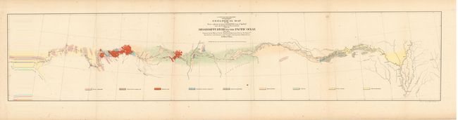
B. Geological Map of the… Mississippi River to the Pacific Ocean…, (8 x 36.5"). This very colorful map details the country from Memphis across the West to the small town of Los Angeles. The underlying geology surveyed by the notable geologist Jules Marcou is delineated and color-coded with a legend across the bottom naming nine formation. The Atchison, Topeka and Santa Fe Railroad later ran along the western part of this survey. A few cities are located along the way; Helena, Napoleon, Vicksburg, Pine Bluff, Little Rock, Fort Smith, San Antonio, Fort Defiance and Needles. The route cuts across the Llano Estacado, north of the Wichita Mountains, and along the edge of the Mogollon Rim, here named the Sierra Mogoyon. Condition - Light scattered foxing and some light toning in the blank margins, else very good. (B+)
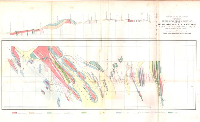
C. Geological Plan & Section from the Rio Grande to the Pimas Villages…, (14.5 x 24"). Ten different geological components found along a stretch of land from El Paso to Maricopa Wells. The tracks of Lt. John G. Parke, of the Topographical Engineers are shown, as is the location of the beautiful Mission San Xavier del Bac near Tucson. The map is also shown as a profile in the upper margin. Condition - Repaired, short intersection tear at left with some creasing at lower left and minor staining in blank areas. (B)
References:
Condition:
All issued folding. See descriptions.