Subject: Cuba and Bahamas
Period: 1775 (circa)
Publication: West-India Atlas
Color: Hand Color
Size:
24.5 x 18.4 inches
62.2 x 46.7 cm
Thomas Jefferys was one of the most important English map publishers of the 18th century. His work included prints and maps of locations around the world, but his most notable maps are of North America and the West Indies. He began his career in the map trade in the early 1730s, working as an engraver for a variety of London publishers, and eventually setting up his own shop. In 1746, he was appointed Geographer to the Prince of Wales, and in 1760 he became Geographer to the King. These titles granted access to manuscripts and cartographic information held by the government. In the early 1760s he embarked on an ambitious project to produce a series of English county maps based on new surveys, but ran out of money and filed for bankruptcy in 1766. He then partnered with London publisher Robert Sayer, who reissued many of Jefferys plates and continued to issue new editions after Jefferys' death in 1771. Jefferys' American Atlas and the accompanying West-India Atlas, published post posthumously, are considered his most important cartographic works.
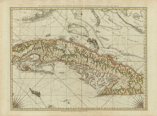
This superb sea chart covers most of Cuba, the southern Florida Keys and Dry Tortugas, part of the Bahamas, and the Cayman Islands. The incredible detail extends to the interior of Cuba to show towns, forts, ranches, roads, and topography. On the southern coast several Hatos are located. Hatos were part of a unique land distribution system in Spanish colonial Cuba. Each Hato consisted of a circular area with a ratio of 2 leagues that was dedicated to the raising of livestock. The nautical information includes soundings, navigational hazards, channels, reefs and notes concerning The Florida Stre (Gulf Stream), and the route of the Spanish galleons, which are pictured in several vignettes. Two partial compass roses anchor the bottom of the chart. This is sheet 7 of Jeffery's 16-sheet chart of the West Indies that formed the heart of this important Revolutionary War period atlas.
References: Cueto #50; Sellers and Van Ee #1784.
Condition: A
A bit of faint toning, else very good.