Subject: Midwest
Period: 1855 (dated)
Publication: Atlas of the World
Color: Hand Color
Size:
15.6 x 12.8 inches
39.6 x 32.5 cm
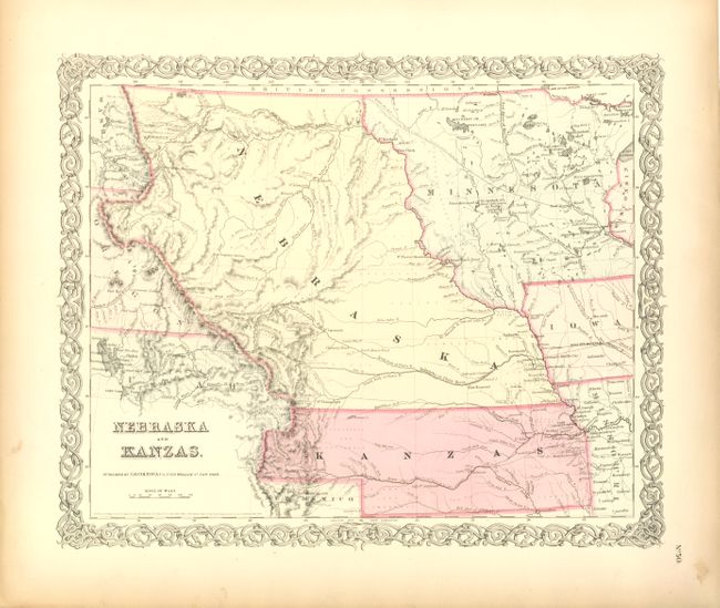
This is the first edition of this important and early map of the transitional territories of Nebraska and Kanzas. In 1854, the United States passed An Act to Organize the Territories of Nebraska and Kansas with this configuration. That act also repealed the Missouri Compromise, allowing slavery in the territories north of the 36° 30´N latitude, provoking violence in the region between pro-slavery and anti-slavery settlers. Nebraska is shown as a massive territory - its northern border to Canada and incorporating the Dakotas west of the Missouri, Wyoming and part of Colorado. Kansas also reaches west to include part of present-day Colorado. Minnesota Territory is shown at its largest extent, with its western border on the Missouri River. The territories are filled with Indian tribes; forts and a few settlements are concentrated along the major rivers. The explored routes for the proposed Pacific railroads are shown. In Wyoming the Rattlesnake Mountains make their first appearance on an atlas map. Locates Fort Laramie and Kearney, to mention a few. Names Cheyenne Pass, Devils Gate and Independence Rock, but South Pass is not mentioned. The map is surrounded in Colton's trademark strapwork border and the verso is blank.
References:
Condition: A
Map image is flawless with original color and nice impression on a full sheet of sound, supple paper. The wide, original margins have a trace of edge toning.