Subject: United States
Period: 1838 (circa)
Publication:
Color: Hand Color
Size:
30.2 x 19.8 inches
76.7 x 50.3 cm
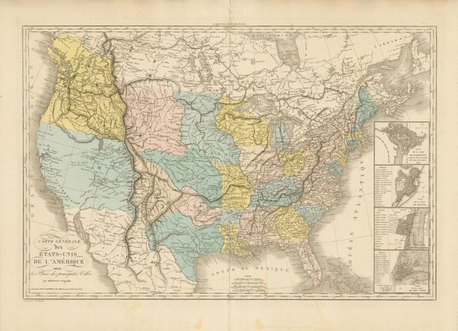
This is a fascinating large format map of the United States with part of Canada. At right are four inset town plans of Washington, Boston, Philadelphia and New York City. The huge Northwest region, controlled by the British is District de la Columbie. It extends from the Columbia River to Queen Charlotte Island and to the Rocky Mountains. The northwest shows excellent geography based on the explorations of Lewis & Clark cartography. Within the region are located many Indian Tribes, early forts and trading posts, accurate river placements, and the route of Lewis and Clark, one of a few maps to do so. It delineates the route from the headwaters of the Missouri to the Columbia River and their return. With several place names along the route including Travellers, Canoe Camp, the Mandan Village visited in 1805 and the point of Observation on the Marie River.
The Rocky Mountain configuration is based on the explorations of Pike and Humboldt. Two lakes, Timanagos and Teguayo, occupy the vicinity of today's Great Salt Lake. Both spawn mythical rivers drawn as dotted lines across the otherwise blank Great Basin, emptying into the Pacific Ocean. A circular road system in the West runs from Santa Fe through parts of Colorado and Utah, naming many Indian villages and pueblos. This road is, in fact, the route of Father Silvestre Velez de Escalante, a Spanish Franciscan missionary, who in 1776-77 setout from Santa Fe seeking a northern route to Monterey in California. In the Independent Republic of Texas the site abandoned by Champ D'Aisle is noted. Also locates the Presidio, St. Antonio, Matagorda and the Pres de Bejar Capital de Texas.
The area of today's Arkansas and Missouri is divided into the four Spanish Land Districts of Arkansas, Laurence, Howard, St. Louis and C. Girardeau. The large area above Texas and today's Arkansas is divided by a dotted line, but the entire region is labeled Arkansas. Overall the map locates a great number of Indian regions including several areas of Apaches, Comanches, Hopi, Ute's, Yabipias, Nochis, Flathead, Shoshones, Shawnees, and many more. Engraved by J.B. Tardieu. Published by A. Bes et F. Dubreuil Fils Editeurs, rue Git-le-Coeur, No. 11. This is a later edition of Herisson's important map of the United States and is without the imprint "1826" in the cartouche. One difference in this edition is the removal of Lac Sale, shown just south of Monterey Bay in the first edition.
References: Wheat (TMW) #371.
Condition: A
On a huge sheet of thick paper with wide, original margins. Fine hand coloring and very nice impression. There is an small area of light staining in the lower, blank margin. Due to thick paper the centerfold has a strong crease or short split in blank margins top and bottom. Map image is fine.