Subject: Caspian Sea, Kamchatka and Japan
Period: 1725 (circa)
Publication: Atlas Maior cum Generales
Color: Hand Color
Size:
22.5 x 19 inches
57.2 x 48.3 cm
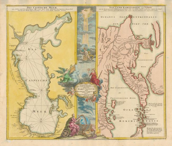
This elegant composition features two maps flanking a very decorative central panel filled with allegorical figures and putti in a cloud background. The map to the left focuses on the Caspian Sea based on the 1722 surveys of Karl van Verden (the first accurate map of the sea). On the right is a map depicting the mythical land of Jedso as part of the Kamchatka Peninsula with a huge unnamed landmass (reminiscent of the Compagnies Land on earlier maps) to the east. This map was the result of the Russian expedition in 1697 that encountered a shipwrecked Japanese in Kamchatka. He told them that Japan was not far from Kamchatka and that the sea between was strewn with islands.
These maps had a great deal of influence on cartography, especially on the cartography of Japan. Among other things, it influenced Kaempfer's editor, Scheuchzer, to introduce the fictitious island of Matsumai. Another interesting feature of the map is found at the bottom of the central panel where one of the cherubs is holding a map of Japan showing the Noto Peninsula turned to the west. This depiction does not appear in actual maps until Bellin's map of Japan in 1736.
References: Walter #120.
Condition: A
There is a short printer's crease the just enters the map at bottom right. The top left corner of the blank margin has been repaired.