Subject: North America
Period: 1856-59 (published)
Publication: Atlas of the World
Color: Hand Color
Size:
13 x 15.5 inches
33 x 39.4 cm
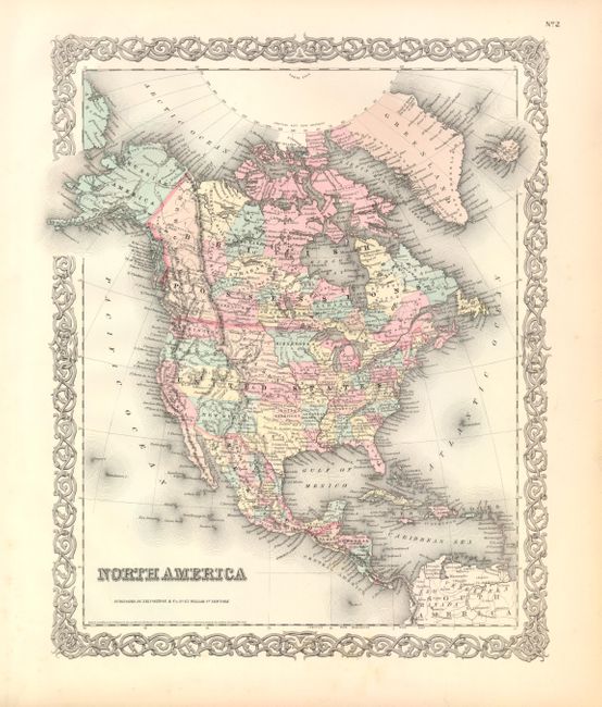
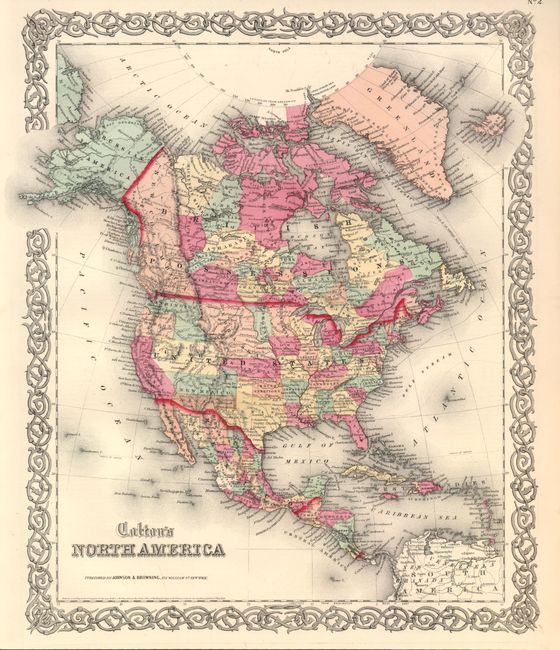
This pair of maps provides a great study of the rapid settlement and changes taking place in the western United States in the span of only four years. Both maps are from the Atlas of the World so are surrounded by Colton's signature scroll-style border.
1) North America, 1855 [1856]. In this attractive steel engraved map the borders and territories are some of the most interesting during the development of the West. The map is filled with political and topographical detail and graphically indicates the rapid changes taking place during this period. The large New Mexico Territory extends between California and Texas, Nebraska stretches between the Continental Divide and Minnesota and north to the Canadian border. Minnesota includes much of the future Dakota territory, bordering the Missouri River. Both Washington and Oregon extend to the Continental Divide, and "Kanzas" reaches the Rocky Mountains at its boundary with Utah. Oklahoma is entirely Indian Territory. No sign of Nevada, Arizona, Colorado, Montana, Wyoming, or the Dakotas. Alaska is Russian America. Excellent detail throughout Canada and Mexico with all states named and individually colored. Names Indian nations, forts, rivers, etc. Published by J.H. Colton.
2) Colton's North America, 1859. After only three or four years the changes in borders from the 1856 map above are remarkable and delineate the rapid changes taking place just prior to the Civil War. Arizona now shows below New Mexico Territory. This is most likely the proposed Arizona rather than the Civil War period Arizona captured by General Baylor and claimed for the confederacy. The newly formed Dakotah Territory has been carved out of Minnesota, while Washington has grown to occupy the land abandoned by Oregon when achieving statehood. The depiction of Alaska, Nebraska, Utah and Oklahoma remain the same as in the early map above. Published by Johnson and Browning in 1860.
References:
Condition: A+
Both are fine.