Subject: North America
Period: 1798 (dated)
Publication:
Color: Hand Color
Size:
28.8 x 20 inches
73.2 x 50.8 cm
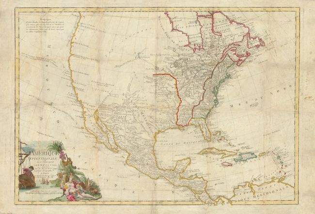
The large map provides a good illustration of the state of geographical knowledge in North America at the end of the 18th century. The region east of the Mississippi valley is well mapped. The United States is shown confined along the eastern seaboard but there is already considerable settlement on the frontier. The entire western part of the continent is marked Pays inconnus (unknown lands), except for the regions of the Southwest that were settled by the Spanish. A River of the West snakes its way from the headwaters of the Mississippi into the blank part of the map, alluding to the sought after Northwest Passage. The west coast is depicted from the discoveries of the Russians and Capt. Cook, with Cook's route of 1778 traced along the northwest coast. The route of the Spanish Manila Galleons is also shown. The title cartouche features ships and a mariner representing trade and commerce, and an allegorical scene of America nursing her children representing the young United States. When first issued in 1779, it was one of the earliest maps to acknowledge the Etats Unis in the title. In this state the imprint includes the post-French Revolutionary date An VII (1798).
References: cf Sellers & Van Ee #167.
Condition: B
The map was folded and well used as a pocket map. It has been professionally flattened with the folds repaired and reinforced on verso including some paper restoration of losses at the fold intersection with a few letters replaced in facsimile. The conservation work was very skillfully accomplished. There is some residual soil in the map.