Subject: Asia
Period: 1632 (dated)
Publication:
Color: Hand Color
Size:
22 x 16 inches
55.9 x 40.6 cm
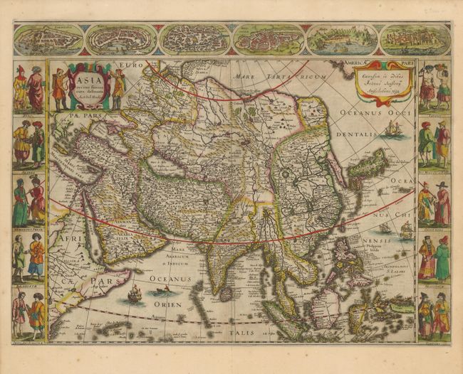
This superb map was first issued in 1623, in response to fierce competition with the Blaeu family whose own carte-a-figures map of Asia was published in 1617. The map conforms to the Blaeu model in most respects, except in the delineation of the northeastern coastline of Asia, which does not extend in to the Arctic. The map extends from the Arabian peninsula through the East Indies. There is a wide expanse of ocean between the east coast of Asia and America, which is conveniently hidden by Jansson's signature cartouche. Korea is shown as a long peninsula and Japan is based on the Ortelius/Teixeira model. The upper border features town plans of the eastern Mediterranean and Middle East and at sides are panels showing various costumes of people throughout the continent. Two hunters flank the title cartouche and the sheet is embellished with European ships, a Chinese sampan and a sea monster. The carte-a-figures version of this map is rare because a new smaller map without the borders, prepared by Henricus Hondius and Jan Jansson in 1631, replaced it in most editions of the Mercator/Hondius atlases. Dutch text on verso.
References: Yeo #25; Tibbetts #83.
Condition: B+
Dark impression and lovely old color. The map has professional, and very skillful paper restoration in the upper two figures and city plan at left. The paper has been seamlessly laid in with the leaf-casting method and part of the figures re-drawn. These repairs are virtually invisible.