Subject: Colorado
Period: 1915 (dated)
Publication:
Color: Printed Color
Size:
23 x 17 inches
58.4 x 43.2 cm
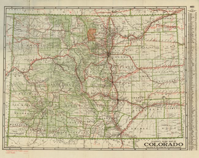
This map of the state has bright, attractive coloring and an index to towns in the right margin that is dated 1915. The map uses red overprinting in different thicknesses to delineate "Transcontinental Roads" and "Local Roads." The map is filled with historic routes including the Pikes Peak Ocean to Ocean Highway, the North and South Route, Rainbow Route, the Hard Pan Triangle Route, and many more.
The automobile was first manufactured in the United States by the Duryea Motor Wagon Company in 1893, and by 1901 Oldsmobile had produced 425 automobiles. The Ford Motor Company, which was organized in June 1903, produced 1,700 cars during its first full year of business. These companies were the pioneers of the automobile industry, and the Clason Map Company was equally a pioneer in the production of maps to meet the growing demand of automobile enthusiasts. The existing bicycle and railroad maps did not serve well this new form of transportation and maps were needed to identify roads suitable for automobiles; roads with adequate gravel, bridges, gasoline and repair shops, etc. In 1905 the American Automobile Association produced the first maps specifically for automobiles and George S. Clason quickly followed suit compiling maps with the assistance of local automobile clubs. This is a nice example of Clason's work geared toward the tourist and auto driver.
References:
Condition: B+
The map has three small fold intersection splits and one 3" split on fold line. Good color and clean example. Covers are sound with no missing paper, but front is a rubbed.