Subject: World
Period: 1646 (dated)
Publication: Theatre Geographique…
Color: Hand Color
Size:
21.5 x 14.8 inches
54.6 x 37.6 cm
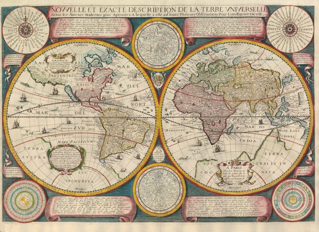
Jean Boisseau's world map marked a major change in cartographic style from the baroque to the more restrained style that gained popularity at the end of seventeen century. The customary allegorical and classical scenes surrounding the map have been replaced with more scientific features. There are two celestial spheres, compass roses displaying the compass points and wind names, panels of text with geographical and astronomical information, a diagram of the heavenly orbits, and a thirty-year calendar beginning in 1637. The geographical details are based on Henricus Hondius' map of 1630. It presents California as an island, no Great Lakes, the Dutch discoveries on the Carpentaria coast of Australia, and Queen Anne's forland (Baffin's Island) on the northeast coast of Canada. The outline of Terra Australis Incognita is still in evidence but Le Maire Strait is shown at the tip of South America. Classical decorative elements within the map have been retained and include numerous sailing ships, sea monsters, and flying fish. This is the rare second state. French text on verso.
References: Shirley #340.
Condition: A+
The right side margin has been professionally extended to better accommodate framing.