Subject: United States and Canada
Period: 1855 (dated)
Publication: The Physical Atlas of Natural Phenomena
Color: Printed Color
Size:
24 x 20 inches
61 x 50.8 cm
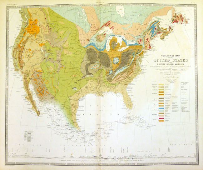
This beautifully engraved and well colored geological map was "Constructed from the most recent documents & unpublished materials." It uses a combination of hand and printed color to delineate at least fifteen different geological formations described in a large table that includes American and the "Nearest European Equivalent" name for each. Below the map is a full-width profile "A Geological Section Across the Appalachian Mts. From the Coast of New Jersey at Egg Harbour to Lake Ontario near the Niagara River." Jillson, writing in 1950, comments that "Fifteen separately colored aerial patterns appear on this map which is sufficiently accurate and detailed to forecast the major outlines of the latest (1932) geological map of the United States. Professor Rogers' map is of excellent cartographic execution, and in lieu of anything better might still be used as a field guide to singular advantage." The geographical units are presented by period with formation names given using both the New York and Pennsylvania systems, then in competition for adoption. The geography presented in the west is a little sketchy as the area was little explored, but represented the best compilation of the time. Rogers was the first State Geologist for the New Jersey and Pennsylvania geological surveys before moving permanently to Scotland. He, with his brother W.B Rogers, was the first to work out the complex structural relationship of the Appalachian Mountains. His "Geology of Pennsylvania, a Government Survey" is one of the great classics in early American geological literature. The map was published by the firm of W. & A.K. Johnston. This large double page map is accompanied by the matching (and still attached) six page folio-sized text sheets which discuss the map in great detail.
References: Marcou & Marcou #51.
Condition: A
The map image is fine: bright color, full margins and no flaws. Printed on thick paper so there is a short marginal split at lower margin that just reaches bottom of border.