Subject: Western Hemisphere
Period: 1618 (circa)
Publication: Descrittione della Geografia Universale
Color: Hand Color
Size:
9.5 x 7 inches
24.1 x 17.8 cm
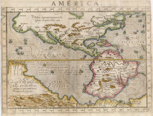
This early map of the Americas is based on Ortelius and D'Anian. The Sierra Nevadas are named and Quivira appears both as a region and a large city in North America. The towns of Marta, Zalisco and Culuacan are noted near present-day New Mexico. Another large city labeled Totonteac is shown at the top of the M. Vermeio (Gulf of California). A wide St. Lawrence River has its headwaters in a tiny lake in the region named Saguenai, and there are no Great Lakes. The names Norinbega for New England, Virginia, Mocosa and Apalche are on the eastern seaboard. Off the coast, the imaginary islands of Frislant, Dos Demonios, Sept Cites and St. Brendain are shown. South America is shown with a bulging western coast from Ortelius, while an outsized La Plata River plunges into the continent. A massive Tierra del Fuego fills the bottom of the map and is connected to an even more massive Nova Guinea, which carries a notation referring to Andrea Corsali, a 15th century Florentine explorer who described and named the Southern Cross. State two with a line encircling the continents, engraved by Girolamo Porro, with his name added in the lower left corner.
References: Burden #86.
Condition: B+
Narrow, but adequate margins, as issued. There are two small areas of paper restoration repairing some worming at upper sides with a tiny bit of the neatlines in facsimile. The map is partially backed with light Japanese tissue reinforcing a crease or fine tear on the left side.