Subject: Russia
Period: 1719 (circa)
Publication: Voyages tres-curieux et tres-renommez faits en Moscovie, Tartarie et Perse
Color: Hand Color
Size:
23.2 x 9.3 inches
58.9 x 23.6 cm
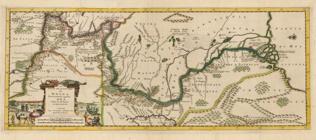
A finely engraved and detailed map showing the course of the Volga River from Novogorod to its entrance in the Caspian Sea. The map is based on Adam Olearius' important map. It is oriented with north to the left by a small compass rose and filled with minute detail along the river. Embellished with a pictorial cartouche of Russian scenery that features a view of Astrakhan, the Persian city at the mouth of the Volga. Printed on two sheets joined, as issued.
As a participant in the German embassy to Moscow and Persia in 1633, Olearius traveled extensively in Russia and Persia. The party's descent of the Volga resulted in the first detailed mapping of the river and Olearius' account of the expedition is one of the most important early accounts of European travels in Russia. His map of the river, then a key area along Europe’s eastern frontier, was widely copied by Jansson and other makers.
References:
Condition: A
Issued folded, now flattened with a couple old paper repairs on folds.