Catalog Archive
Auction 131, Lot 419

"Nieuwe Paskaart van de Kusten van West Indien van Rio Oronoque tot Cartegena Met alle de Caribische Eylanden. Als meede Porto Rico en de Zuyd Kust van Espaniola…", Keulen, Johannes van

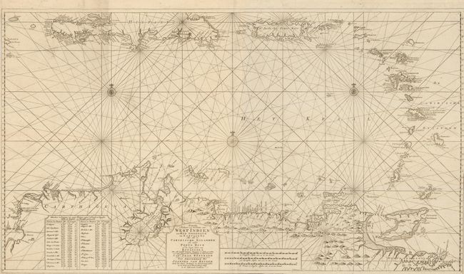
Subject: Caribbean and Northern South America

Period: 1734 (circa)

Publication:

Color: Black & White

Size:
39.8 x 23 inches
101.1 x 58.4 cm
Download High Resolution Image
(or just click on image to launch the Zoom viewer)

This superb large sea chart focuses on the eastern part of the Caribbean Sea. The chart provides a detailed view of the coastlines with anchorages, shoals, soundings and other navigational information carefully noted. The chart was apparently first compiled in the latter part of the 17th century and then updated here with information from Captain Jean Bertrand who sailed between the Netherlands and the West Indies from 1726-1734. The Van Keulens often used information gathered from hydrographers and sea captains for their charts. Until the opening of the Dutch Hydrographic Office in the 19th century, the Van Keulen firm issued what were regarded as the official Dutch sea charts. Printed on two sheets, as issued.

References:

Condition: A+

Issued folded with narrow, but adequate, side margins.

Estimate: $1,800 - $2,200

Sold for: $1,700

Closed on 3/17/2010

Archived