Subject: Boston, Massachusetts
Period: 1776 (dated)
Publication: Town & Country Magazine,
Color: Black & White
Size:
16.3 x 12.3 inches
41.4 x 31.2 cm
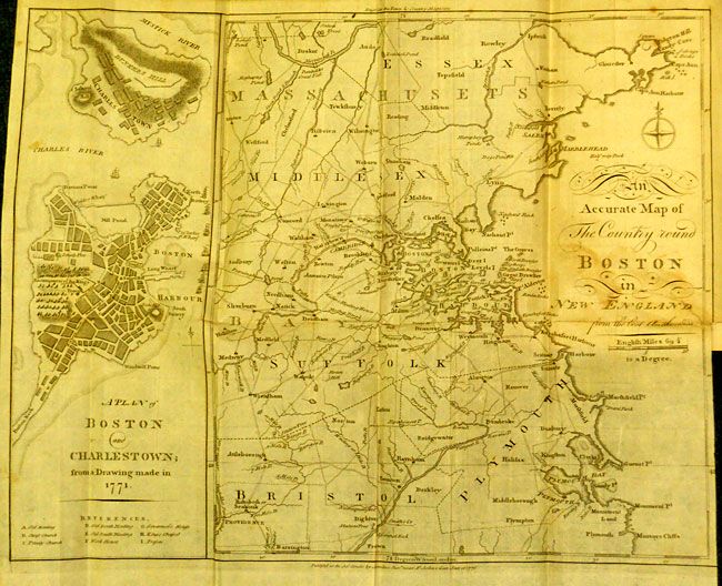
Very uncommon Revolutionary War map made for the January 16th, 1776 edition of Town & Country Magazine, with two maps on one sheet. The map on the left was based on a 1771 drawing of the city just after the Boston Massacre of 1770, and shows Boston and Charlestown with the major streets and buildings named, including Faneuil Hall. An encampment of Redcoats are shown right next to a small depiction of the Liberty Tree. The Liberty Tree was an elm tree located at about Washington and Essex streets and used as a meeting place by the Sons of Liberty, who formed after the Stamp Act if 1765. The tree was attacked by British Loyalists in 1775 and burned, but remained a popular symbol, encouraging other colonialists to erect Liberty poles, hung with flags depicting the Liberty Tree. After the massacre, all British soldiers were moved out to a fort on Castle Island to avoid additional unrest. The second map shows the surrounding countryside from Ipswich, Gloucester and Cape Ann down to Plymouth, and as far west as Providence and Groton. A scarce and fascinating map published at the birth of the United States.
This map is still bound into original The Town and Country Magazine; or Repository of Knowledge, Instruction, and Entertainment, Vol. VIII for the Year 1776, 12 monthly issues plus supplement, London: Printed for A. Hamilton, Junr. In original (?) half leather and marbled boards, octavo, 716, [12] index pp. plus 25 (of 26) engraved plates, including 2 maps of Boston on one folding sheet. Also contains "A View of New York, Governors Island, the River &c. from Long Island" accompanying the article A Detail of the Battle at Long Island, on p. 537. The volume is lacking plate "A Plan of the Court for the Trial of Elizabeth Duchefs."
References: Jolly TOWN-2; Sellers & Van Ee #894; Nebenzahl (Biblio) #14 & 14a.
Condition: B+
Map with an old repaired tear and some toning or staining to the sheet. The contents are is tight and binding is very nice with a little wear and abrasion to spine.