Subject: Southwestern United States
Period: 1863-64 (circa)
Publication: Illustrated Family Atlas
Color: Hand Color
Size:
24.5 x 17 inches
62.2 x 43.2 cm
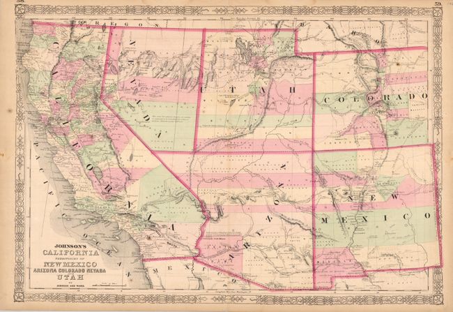
This is the late 1863 - early 1864 edition in this series of maps. Arizona still commands the Southern tip of Nevada and has the county configurations of the old New Mexico Territory, with the addition of Castle Dome and Ewell counties in the south. The Colorado Gold Mines are located in Castle Dome counties adjacent to the Colorado River. The Utah/Nevada border is now at 115°. This is a completely new plate with much changed in watershed and mountain detail and several of the earlier notations removed. Details the U.S. Mail routes, the Emigrant roads to California, the proposed railroad route through Utah, Nevada and California, and the Pony Express trail. In the southern part of Arizona is the "Gadsden Ten Million Purchase of Mexico." The map is filled with historic and interesting notations. One note in the area of Quartzite, Arizona refers to the area as being "exceedingly fertile and abundantly timbered and well watered." Another in southern Nevada says "This vast Unexplored Region of country is supposed to be inhabited by tribes of Indians. Altitude nearly 5000 feet."
References:
Condition: B+
Very nice example with just a few spots and some very light offsetting.