Subject: Northwestern United States
Period: 1893 (dated)
Publication: Ex. Doc. No. 7, 53rd Congress, 1st Session
Color: Printed Color
Size:
6 x 9 inches
15.2 x 22.9 cm
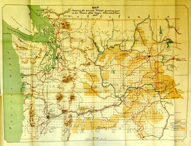
This report is from Daniel S. Lamont, Secretary of War to President of the United States Senate. It contains the detailed report of E.P. Alexander related to the obstructions on the Columbia river from Three Mile Rapids to above Celilo Falls. The first map is "Map Showing the present Wheat Growing area in the Basin of the Upper Columbia River," 29 x 22". This large and colorful map shows the entire state of Washington and extends to below Salem, Oregon. Delineates the wheat belts with burnt umber color, RR's in red and water in green. Good detail of RR's in operation at the time and filled with detail and survey information. Other plates include "Transport Car for Boat Railway at the Dalles of the Columbia River" which are detailed drawings of a transport system as described in Lieut. Edward Burr's 5pp report, which follows the main report. The final map, a huge production at 173" x 27", titled "Map of Survey for Boat and Portage Railways. The Dalles -- Celio Oregon." The map is beautifully colored in several colors, unusual for a government map from this period, and composed of several joined sheets, as issued. At over 14 feet long this is the widest map of it's type we have seen. 8vo, 17pp, 6 folding plates and maps, and large folding map.
References:
Condition: A+
The report is disbound and the huge "Railways The Dalles…" map is loose from the booklet. Contents and maps are fine with no foxing or staining. Exceptional condition, especially considering the huge folding map.