Subject: United States & Canada
Period: 1870 (dated)
Publication:
Color: Hand Color
Size:
41 x 14.8 inches
104.1 x 37.6 cm
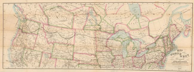
This uncommon map details the route of the Northern Pacific Railway from Michigan's U.P. to Portland, Seattle and Olympia. The map stretches from New England to the Pacific, south to include San Francisco and Denver, and into Canada showing most of British Columbia and all of Alberta, Saskatchewan, Winnipeg, Moose, Bittibee and most of James Bay. The map is remarkably detailed with all rails throughout the area delineated as well as the watershed, wagon roads and many towns named. Iso-thermal lines give the mean annual temperature in 10°F increments. With many interesting notations including the location of coal in several places, the winter home of buffaloe, and locates various land types including pasture, and timber. One notation suggest northeastern Montana is an area of "Wide & fertile Valley well timbered." Lithography by the N.Y. Lithographic, Engraving and Printing Co. of Julius Bien. The map is hand colored in outline, a rarity for the Julius Bien company.
References:
Condition: B
Folded as issued. Several fold intersection splits and one fold panel with multiple small breaks along a fold and toned where apparently attached to pocket map cover. The balance of the map is very nice. Map will benefit from professional backing.