Subject: Western Hemisphere, Pacific and Atlantic Oceans
Period: 1740 (circa)
Publication:
Color: Hand Color
Size:
36.8 x 23.3 inches
93.5 x 59.2 cm
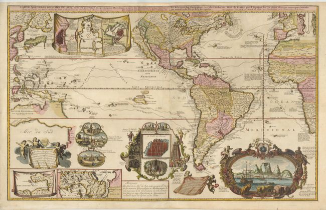
De Leth's extraordinary map is one of the most decorative ever engraved. This magnificent map is partly based on de Fer's extremely rare 1698 wall map. It is centered on the Americas and includes both the Atlantic and Pacific Ocean basins; thus including the western parts of Europe and Africa and the eastern coast of Asia, part of the East Indies, and part of Australia and New Zealand. Cartographically, it follows French models and presents the island of California on the Sanson model. The British colonies are confined to the Atlantic coast with the French controlling the broad middle of North America. The Great Lakes are well formed and the Mississippi flows into the Gulf on Mexico on the Texas coast. In the Pacific the mythical Terre de Quir is nearly joined to the northern coastline of Australia, and the southwestern coastline (with notations of the Dutch discoveries of the early 17th century) is joined with the coastline of New Zealand forming a wildly inaccurate landmass. Overall the map includes a wealth of geographical and historical information, including commercial sea routes and the paths of famous explorers. There are six detailed inset plans of the important port cities of Veracruz, Rio de Janeiro, and Havana, the bay of Porto Bello, the isthmus of Panama, and the Strait of Gibraltar. One cartouche at lower center is surmounted by a plan of Mexico City surrounded with scenes of cannibalism and human sacrifice, and another elaborate cartouche contains a dramatic view of Table Bay at the Cape of Good Hope. The map is a tour de force of decorative mapmaking and a spectacular example of the golden age of Dutch cartography.
Andries de Leth, and his son Hendrik, took over the business of Nicholas Visscher and shortly thereafter produced this magnificent, two-sheet map. The map was not published in any of de Leth's atlases and that accounts for its rarity. As a large separately issued map, subject to the fate of any document unprotected by a binding, it is rarely found in excellent condition. This is the third state, with the inset city plans replacing a vignette of Niagara Falls and the publisher's imprint below the title .
References: McLaughlin #220; Norwich #320; Tooley (Amer) p. 133, #94; Tooley (MCC-23) #75.
Condition: B+
A section at top center (7 x 2") has been expertly and very skillfully restored with superb facsimile of part of the title and part of the map. There is also minor paper restoration along the joint at center and at a couple of places where the map has been folded. This restoration was all done professionally and to the highest standard of workmanship. The original color has been slightly refreshed.