Subject: Java, Indonesia
Period: 1817 (dated)
Publication: The History of Java
Color: Hand Color
Size:
44 x 16 inches
111.8 x 40.6 cm
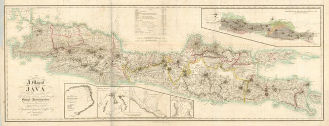
While serving as Lieutenant Governor in Indonesia, Raffles documented the island’s history, culture, architecture and contemporary civilization. His observations were published in a two-volume study that included this fine map of the island. The topography is particularly well represented, along with the locations of hundreds of villages, temple ruins, safe anchorages, and roads. It also shows the route Raffles used in 1815 to rediscover and restore Borobudur and other ancient monuments. An inset at upper right provides a mineralogical and teak forest sketch of the island by Dr. Thomas Horsfield in 1812. Another inset details major bays and harbors.
References:
Condition: B+
Original outline color with some minor offsetting. Folded as issued with a few short intersection splits. The binding trim at upper left has a short tear that just touches the neatline.