Subject: Oklahoma
Period: 1837 (dated)
Publication: Se. Doc. 120, 25th Cong., 2d Sess.
Color: Black & White
Size:
19.8 x 10.8 inches
50.3 x 27.4 cm
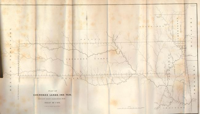
This is one of the earliest printed maps to depict present day Oklahoma in any detail. It shows a track of land that extends from the borders of Missouri and Arkansas to the "Western Limits of the United States" (100° W. Longitude from Greenwich). The map was drawn at the conclusion of the "Trail of Tears" and shows the furthest extent of the land reserved to the Cherokees, as well as several other reservations (part of which are in what is present-day Kansas). A terrific and early Indian Territory map surveyed by J.C. McCoy under Isaac McCoy's direction, dated in the plate Sept. 20th, 1837. The map is still bound in the original, complete document "Report from the Secretary of War in Compliance with a Resolution of the Senate of the 13th October, 1837 in Relation to the Cherokee Treaty of 1835," by Blair and Rives, Printers, 1090 pp. with folding engraved map (at p. 952).
References:
Condition: B+
The map is sound but has scattered light foxing. The report with covers lacking, missing a large portion of page 3/4, and the title page torn with some edge chipping. Contents tight and pages generally very good.