Subject: Colonial United States and Canada
Period: 1758 (published)
Publication: Grand Magazine of Magazines
Color: Black & White
Size:
7.5 x 4.3 inches
19.1 x 10.9 cm
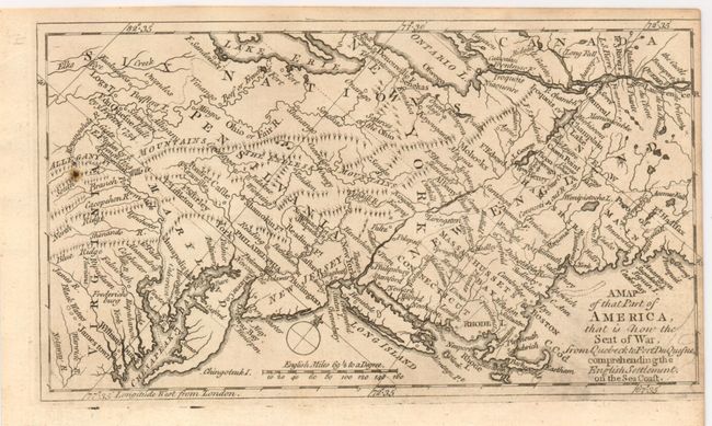
This map covers the northeastern part of the United States down to Virginia and focusing on the areas of conflict in the French and Indian War. A great deal of the conflict was focused around the upper Hudson and Lake Champlain, and along the St. Laurence River. The map locates numerous forts involved in the war, including William Henry, Edward, and S. Frederick. Two unnamed forts are shown south of Lake Erie. Notes the sources of the Ohio River, locates "the Castle" as well as many other interesting place names. All these details and topographical information were important to the contemporary reader following the war from across the Atlantic. This map was published in the rare Grand Magazine of Magazines in the November 1758 issue. The related article "Description of the Map of America" notes "The intelligent reader, in the course of this work, will have frequent occasion to consult this little map, which is much easier referr'd to, than map of larger dimensions." A rare issue from this short-lived publication.
References: Jolly GMOM-13.
Condition: A
A little darkening along bottom from ink on plate.